


WBGB Aerodrome Obstacles Chart – ICAO Type A
Obstacles within the take-off area of an aerodrome up to 10 km from the end of the runway.
Product is added into your Cart.
CAAM has produced the AIM Data Catalogue based on the ICAO PANS-AIM Appendix 1 to facilitate its usage by civil aviation authorities, air navigation service providers, and data originators in implementing a fully data-centric AIM environment.
CAAM has produced the AIM Data Catalogue based on the ICAO PANS-AIM Appendix 1 to facilitate its usage by civil aviation authorities, air navigation service providers, and data originators in implementing a fully data-centric AIM environment. We have included mapping the data elements to the current version of AIXM 5.1, which was initially developed by EUROCONTROL and further maintained by the AIXM Community. CAAM AIM Data Catalogue provides the CAAM AIP in AIXM 5.1 format based on ICAO PANS-AIM (Doc 10066), First Edition 2018, including Amendment 1
ICAO AIM Data Catalogue references: https://www.datacat.aero
CAAM's AIM Portal and ETOD Data: Elevating Malaysian Aviation with Precision and Safety

Obstacles within the take-off area of an aerodrome up to 10 km from the end of the runway.
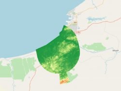
Matrix of points that determine the correlated elevation of the ground around the Aerodrome. Represents bare earth surface.
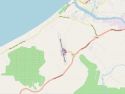
Nodes and edges of the Associated Aerodrome Surface Routing Network. This represents a subset of an aerodrome that is suitable for taxiing special-seized aircraft.
Aeronautical Information Services Unit, Civil Aviation Authority of Malaysia, Persiaran Korporat KLIA, 64000, KLIA, Sepang, Selangor.
+603 8871 4000 ais@caam.gov.my
